Unit 1: Redefining World Society and Culture
Lesson E: Travel and Trade in the Pre-Modern Era
Activity 4: Trading Networks Prior to the 15th Century

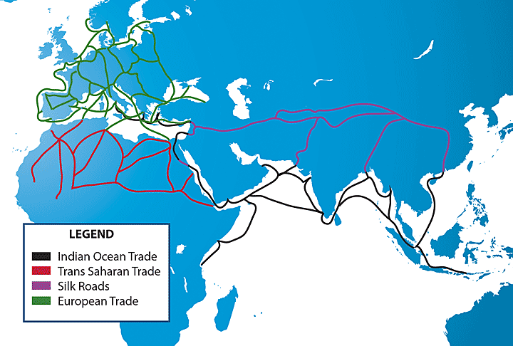
Map of Major Trade Routes in Afro-Eurasia During the Middle Ages [1]
Written Activity - Notebook
Examine the map above that shows major trade routes in the Afro-Eurasia during the Middle Ages. Use this map to help you answer the following questions in your notebook:
- In what ways was the pre-modern world connected?
- How do you think traders traveled along these routes? What forms of transportation did they most likely use?
- What impact do you think traveling along these trade routes had on the people who worked as traders and merchants?
- What impact do you think traders and merchants traveling along these routes had on people living in the lands along trade routes?
- What parts of the world do not appear to be involved in these trade networks? Why do you think they were not involved?
Classroom Activity - Trade Routes
![]() Jigsaw
Jigsaw
Directions: In this activity, you will complete a jigsaw activity in a group to learn about some of the trade routes found in Africa, Asia, and Europe. While working in your group, you will be responsible for teaching others and learning from others. Use the fact sheets to study information about these regions. Your teacher may assign additional research about these regions.
Download the Student Resource: Trade Routes Jigsaw (pdf).
Download the Student Resource: Trade Routes Jigsaw Organizer (doc).
![]() Discussion
Discussion
Directions: Prepare a response to the discussion questions below. Follow your teacher’s directions to participate in your class discussion.
- How was the world connected during the pre-modern world?
- How important was trade to the interaction of the pre-modern world?
- How did trade routes impact economic development in the pre-modern world?
- How did trade lead to cultural and technological diffusion in the pre-modern world?
- Why is understanding about the impact of trade routes important in our study of world civilizations?
Select the link to review the Discussion Scoring Tool (pdf).
Page Notes:
[1] Source: This image was created based on the following three maps which are in the public domain:
http://commons.wikimedia.org/wiki/File:Silk_route.jpg
http://commons.wikimedia.org/wiki/File:Niger_saharan_medieval_trade_routes.PNG
http://commons.wikimedia.org/wiki/File:Late_Medieval_Trade_Routes.jpg

